
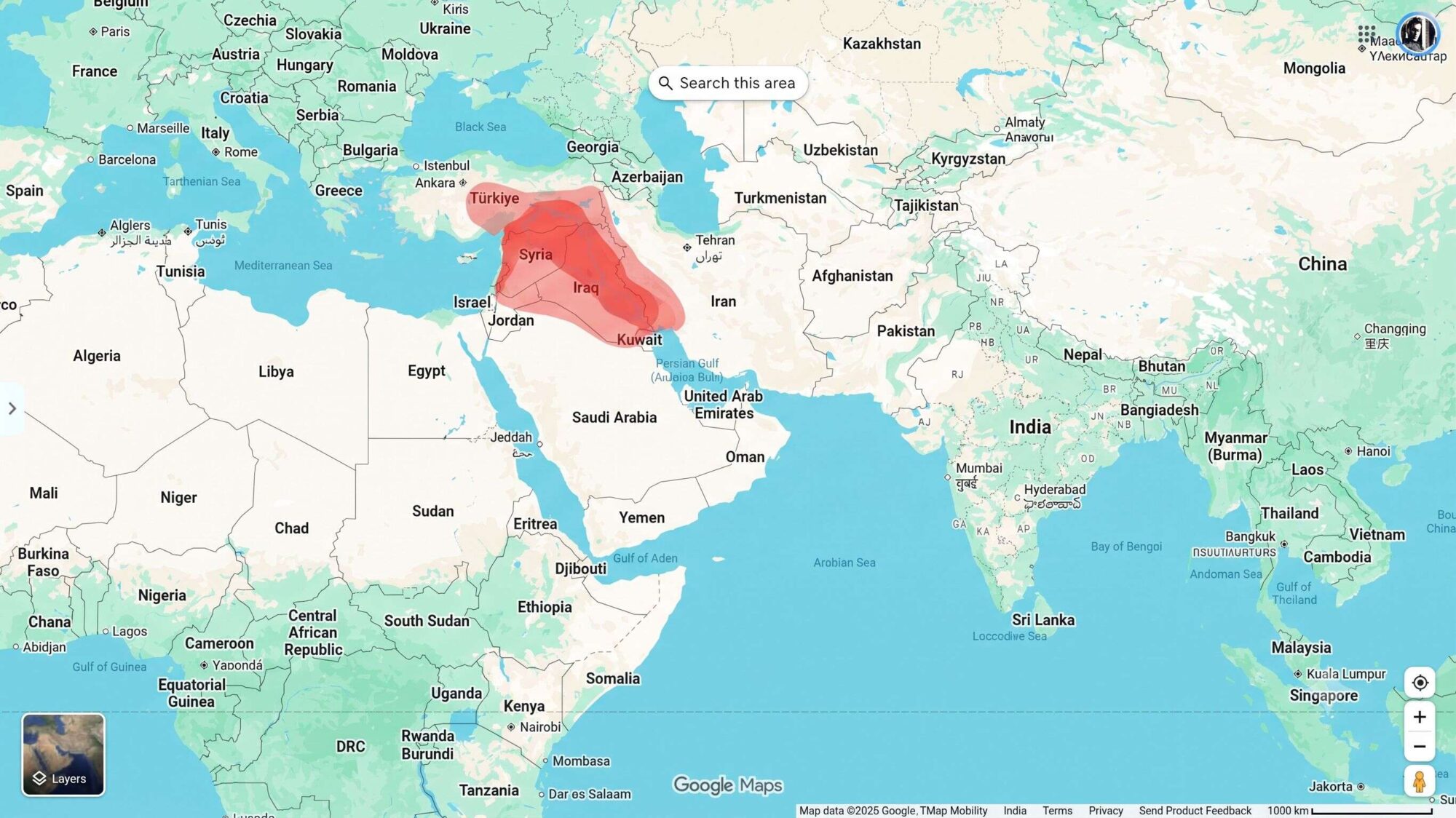
Ancient Mesopotamia—often called the “Cradle of Civilization”—spanned over 4,000 years, from the rise of the world’s first cities to its absorption into external classical empires:
Because Mesopotamia was not governed by a single unbroken state, its history is defined by successive civilizations and empires that dominated the Tigris–Euphrates basin: the Early Sumerian City-States, the Akkadian Empire, the Neo-Sumerian Third Dynasty of Ur (Ur III), the Old Babylonian Empire, the Middle & Neo-Assyrian Empires, and the Neo-Babylonian Empire.
Below is a chronological table of the most prominent rulers of ancient Mesopotamia across its major imperial periods, with standard historiographical estimates of the land area under their direct rule or hegemony:
1. Early Dynastic Sumer & Akkadian Empire (c. 2500 – 2154 BCE)
| No. | Ruler Name | Reign Period | Estimated Land Area Under Reign |
| 1 | Eannatum of Lagash | c. 2450 BCE | ~5,000 – 10,000 km² (First regional Sumerian hegemon; “Stele of the Vultures”) |
| 2 | Lugalzagesi of Umma & Uruk | c. 2350 – 2334 BCE | ~40,000 – 60,000 km² (Unified the city-states of Sumer) |
| 3 | Sargon of Akkad (Sargon the Great) | c. 2334 – 2279 BCE | ~650,000 – 800,000 km² (Founded the Akkadian Empire; Persian Gulf to Mediterranean) |
| 4 | Rimush & Manishtushu | c. 2278 – 2255 BCE | ~600,000 – 700,000 km² |
| 5 | Naram-Sin | c. 2254 – 2218 BCE | ~800,000 – 1,000,000 km² (Akkadian peak; proclaimed “King of the Four Quarters”) |
| 6 | Shar-Kali-Sharri | c. 2217 – 2193 BCE | ~400,000 – 500,000 km² (Decline under Gutian raids) |
2. Neo-Sumerian Renaissance & Old Babylonia (c. 2112 – 1595 BCE)
| No. | Ruler Name | Reign Period | Estimated Land Area Under Reign |
| 7 | Ur-Nammu (Third Dynasty of Ur) | c. 2112 – 2095 BCE | ~150,000 – 200,000 km² (Codified earliest known law code; built Great Ziggurat of Ur) |
| 8 | Shulgi of Ur | c. 2094 – 2047 BCE | ~250,000 – 300,000 km² (Neo-Sumerian imperial peak; consolidated southern/central Iraq and Elam border) |
| 9 | Ibbi-Sin | c. 2028 – 2004 BCE | ~30,000 km² → collapsed (Fall of Ur to Elamites and Amorites) |
| 10 | Shamshi-Adad I (Old Assyria) | c. 1808 – 1776 BCE | ~250,000 – 300,000 km² (Kingdom of Upper Mesopotamia) |
| 11 | Hammurabi of Babylon | c. 1792 – 1750 BCE | ~400,000 – 500,000 km² (Unified all Mesopotamia: Sumer, Akkad, Mari, Assyria; Code of Hammurabi) |
| 12 | Samsu-iluna | c. 1750 – 1712 BCE | ~250,000 – 300,000 km² (Lost southern Sumer to the Sealand Dynasty) |
3. Middle & Neo-Assyrian Empire (c. 1365 – 609 BCE)
| No. | Ruler Name | Reign Period | Estimated Land Area Under Reign |
| 13 | Ashur-uballit I | c. 1365 – 1330 BCE | ~150,000 – 200,000 km² (Rise of the Middle Assyrian Empire) |
| 14 | Tukulti-Ninurta I | c. 1243 – 1207 BCE | ~350,000 – 450,000 km² (Sacked Babylon; ruled northern and southern Mesopotamia) |
| 15 | Tiglath-Pileser I | c. 1114 – 1076 BCE | ~300,000 – 400,000 km² |
| 16 | Ashurnasirpal II | 883 – 859 BCE | ~400,000 – 500,000 km² (Rebuilt Nimrud/Kalhu as imperial capital) |
| 17 | Shalmaneser III | 859 – 824 BCE | ~550,000 – 650,000 km² |
| 18 | Tiglath-Pileser III (Pulu) | 745 – 727 BCE | ~800,000 – 950,000 km² (Created permanent standing army; annexed Syria and Babylonia) |
| 19 | Sargon II | 722 – 705 BCE | ~1,000,000 – 1,150,000 km² (Founded Sargonid Dynasty; built Dur-Sharrukin) |
| 20 | Sennacherib | 705 – 681 BCE | ~1,100,000 – 1,200,000 km² (Made Nineveh royal capital; destroyed Babylon) |
| 21 | Esarhaddon | 681 – 669 BCE | ~1,300,000 – 1,400,000 km² (Conquered Lower Egypt/Memphis) |
| 22 | Ashurbanipal | 668 – 627 BCE | ~1,400,000 – 1,500,000 km² (Peak of Assyrian Empire; Royal Library of Nineveh; Egypt, Levant, Mesopotamia, Elam) |
4. Neo-Babylonian / Chaldean Empire (626 – 539 BCE)
| No. | Ruler Name | Reign Period | Estimated Land Area Under Reign |
| 23 | Nabopolassar | 626 – 605 BCE | ~500,000 – 650,000 km² (Allied with Medes to overthrow Assyria; restored Babylonian independence) |
| 24 | Nebuchadnezzar II | 605 – 562 BCE | ~900,000 – 1,000,000 km² (Neo-Babylonian peak; conquered Levant, Jerusalem; Ishtar Gate & Etemenanki) |
| 25 | Amel-Marduk (Evil-Merodach) | 562 – 560 BCE | ~900,000 – 950,000 km² |
| 26 | Neriglissar | 560 – 556 BCE | ~900,000 km² |
| 27 | Labashi-Marduk | 556 BCE | ~900,000 km² |
| 28 | Nabonidus (with Belshazzar) | 556 – 539 BCE | ~900,000 km² → 0 km² (Last native ruler of ancient Mesopotamia; Babylon fell to Cyrus the Great of Persia) |
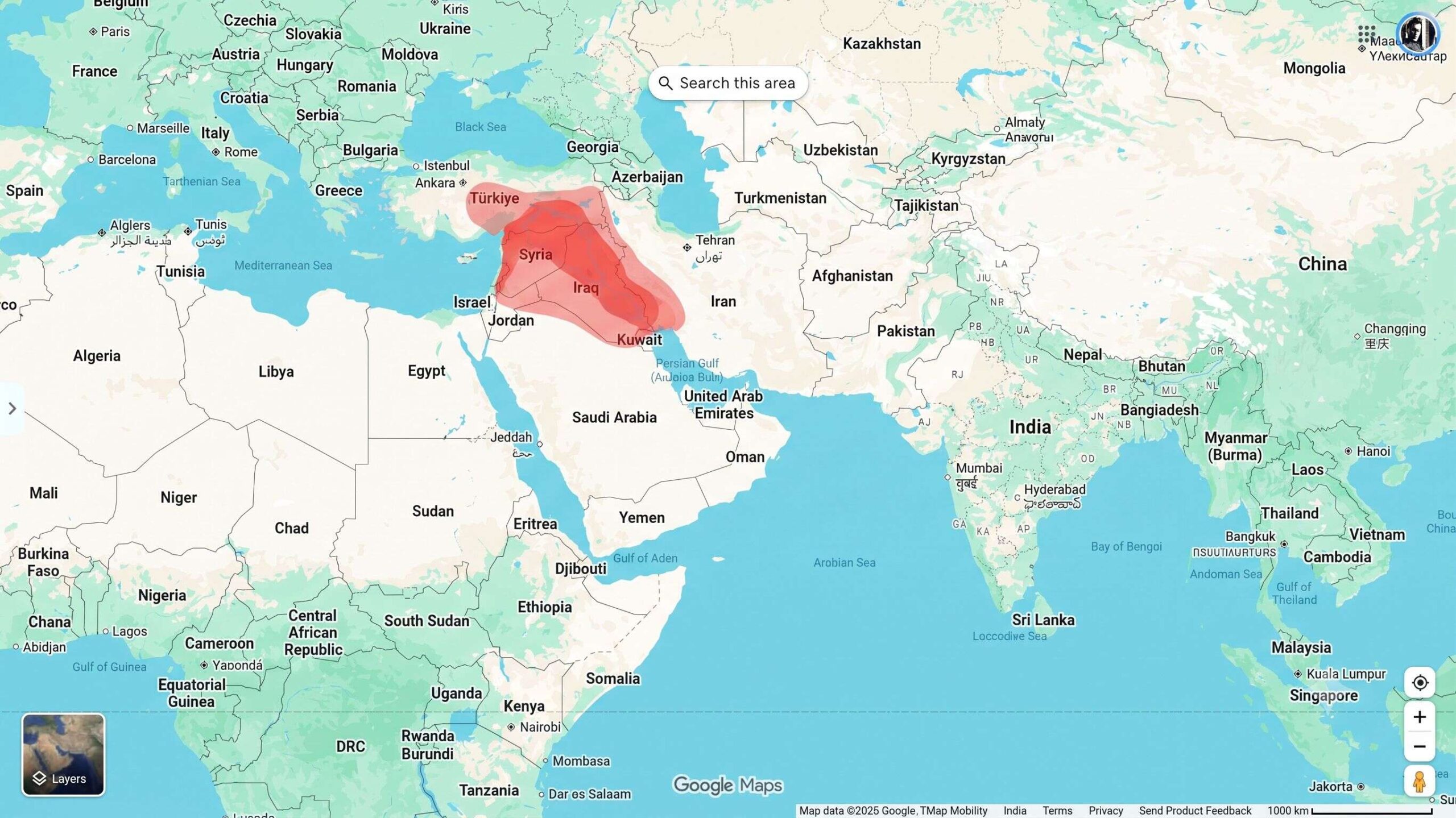
1. The Dark Red Area: Core Mesopotamia
The deeper, more saturated red traces the Tigris and Euphrates river valleys—the true geographic definition of Mesopotamia (“the land between the rivers”).
- Lower Mesopotamia (Sumer, Akkad, Babylonia): The southern alluvial plain stretching from central Iraq down to the Persian Gulf. This is where dense canal irrigation allowed the world’s earliest cities (Ur, Uruk, Babylon, Eridu) to flourish.
- Upper Mesopotamia (Assyria / Al-Jazira): The northern rolling plains along the Tigris and middle Euphrates (extending up toward Mosul and northern Iraq), which formed the imperial core of the Assyrian civilization.
2. The Lighter Red Area: Borderlands & Sphere of Influence
The lighter, semi-transparent red covers the broader territories that were culturally, economically, or politically tied to Mesopotamia, but lie outside the central river basin:
- Southeastern Anatolia (Modern Türkiye): The rugged mountain highlands where the Tigris and Euphrates rivers originate.
- Western Syria & Northern Levant: Regions along the Syrian desert steppe and the western Euphrates bend (such as around Ebla, Mari, and Aleppo) that traded extensively with or were periodically controlled by Mesopotamian empires like Akkad and the Neo-Assyrians.
- Western Foothills / Zagros Rim: The eastern buffer bordering the Iranian plateau and ancient Elam.
In short, the dark red marks the central river-floodplain heartland where Mesopotamian urban civilization developed, while the light red shows the surrounding watershed and frontier regions influenced by it.
Foundational & Urban Era (c. 5000 BCE – 2334 BCE):
- Ubaid & Uruk Periods (c. 5000–3100 BCE): Transition to permanent irrigation agriculture, founding of the earliest cities (such as Eridu and Uruk), and the invention of cuneiform writing.
- Early Dynastic Period / Sumerian City-States (c. 2900–2334 BCE): Rise of independent rival city-states including Ur, Lagash, Kish, and Uruk.
The Imperial Eras (c. 2334 BCE – 539 BCE):
- Akkadian Empire (c. 2334–2154 BCE): Founded by Sargon of Akkad, widely regarded as history’s first multinational empire.
- Old Babylonian Empire (c. 1894–1595 BCE): Famous for King Hammurabi and his legal code.
- Assyrian Empires (Middle & Neo-Assyrian, c. 1365–609 BCE): A dominant military power centered in northern Mesopotamia with capitals at Ashur, Nimrud, and Nineveh.
- Neo-Babylonian Empire (626–539 BCE): Reigned under Nebuchadnezzar II (building the Ishtar Gate and the Hanging Gardens of Babylon).
Classical & Late Antiquity Transition (539 BCE – 651 CE):
- Ended as an independent political entity when Babylon fell to Cyrus the Great of Persia in 539 BCE.
- Remained a vital province (often called Babylonia or Asoristan) through the Seleucid, Parthian, and Sasanian periods until the 7th-century Islamic conquests.
Modern-Day Countries and Regions Included
The name Mesopotamia is derived from ancient Greek (Meso-potamia), meaning “the land between the rivers”—specifically the Tigris and Euphrates basins.
1. Core Nations (Substantially / Fully Covered)
A. Iraq: The heartland of ancient Mesopotamia.
- Southern Mesopotamia (Sumer & Akkad / Babylonia): Encompasses modern cities and regions like Basra, Najaf, Karbala, Hillah, and Baghdad.
- Northern Mesopotamia (Assyria / Subartu): Encompasses Mosul, Erbil, Kirkuk, and the fertile plains leading up to the Zagros mountains.
B. Syria:
- Eastern and Northeastern Syria (Upper Mesopotamia / the Jazira): Spans the Euphrates and Khabur river valleys, including Deir ez-Zor, Raqqa, and Al-Hasakah.
2. Borderlands and River Headwaters
A. Türkiye (Southeastern Anatolia):
- The headwaters and highlands where the Tigris and Euphrates rivers originate, including modern provinces such as Şanlıurfa, Diyarbakır, Gaziantep, and Mardin.
B. Kuwait:
- The northern marshy and coastal perimeter buffering Bubiyan Island and the mouth of the Shatt al-Arab delta at the Persian Gulf.
C. Iran (Western Border Fringe):
- The low-lying alluvial plains of Khuzestan (ancient Elam / Susiana), which topographically and culturally were closely intertwined with lower Mesopotamian city-states.
Key Ancient Cities Across the Map
- Ur: Birthplace of monumental ziggurats and early dynastic royal tombs (southern Iraq).
- Uruk: One of history’s first major metropolises (southern Iraq).
- Babylon: Legendary capital of Hammurabi and Nebuchadnezzar II (near modern Hillah, Iraq).
- Nineveh: The imperial capital of the Neo-Assyrian Empire (modern Mosul, Iraq).
- Mari: Key trade hub connecting Mesopotamia and the Levant (eastern Syria near Abu Kamal).
- Harran: Ancient commercial and religious center dedicated to the moon god Sin (southeastern Turkey).
